

Preview
Publication Date
3-2-2009
Description
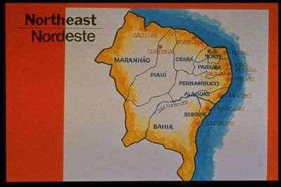
Map slide depicting the Northeast region. The Northeast region comprises the nine states of Maranhão (MA), Piauí (PI), Ceará (CE), Rio Grande do Norte (RN), Paraíba (PB), Pernambuco (PE), Alagoas (AL), Sergipe (SE) and Bahia (BA) and the territory of Fernando de Noronha (FN), an arquipélago 345 km off the mainland. It covers 18% (1,548,672 sq. km) of the national territory. The topology of the area offers a variety of contrasts and four major subregions can be identified: the zona da mata, agreste and the sertão.Mapa mostrando a região Nordeste. A região Nordeste compreende nove estados: Maranhão (MA), Piauí (PI), Ceará (CE), Rio Grande do Norte (RN), Paraíba (PB), Pernambuco(PE), Alagoas (AL), Sergipe (SE), e a Bahia (BA). Além destes estados também faz parte da região Nordeste o território de Fernando de Noronha (FN), um arquipélago, localizado a 345 km do continente. O Nordeste cobre 18% (1.548.672 km quadrados) do território nacional. Sua topologia proporciona uma variedade de contrastes, podendo distinguir quatro sub-regiões importantes: o meio-norte, a zona da mata, o agreste e o sertão.
Publisher
Latin American and Iberian Institute / University of New Mexico
Rights
Brazil Slide Series Collection: This article is copyrighted by the Latin American & Iberian Institute (LAII) of the University of New Mexico. Rights permission is for standard academic, non-commercial, use of these materials. Proper citation of this material should include title, author, publisher, date, and URL. Copyright Latin American and Iberian Institute University of New Mexico 1988
Keywords
Brazil: Introduction to Brazil
